Iran nuclear and military damage revealed after restricted satellite images released
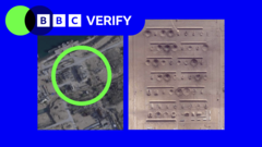
•Iran nuclear and military damage revealed after restricted satellite images released ByMerlyn Thomas, Barbara Metzler, Benedict Garman and Alex MurrayPublished7 minutes agoThe extent of damage to some...
•Other images show destroyed aircraft and sunken ships.
•Craters can also be seen on multiple runways, including at Bushehr International Airport - some of which have since been repaired.In some areas - designated as "military" on online maps like OpenStree...
هذا الخبر من BBC News. خبر يقدم أدوات ذكاء اصطناعي للتلخيص والترجمة والاستماع.
Iran nuclear and military damage revealed after restricted satellite images released ByMerlyn Thomas, Barbara Metzler, Benedict Garman and Alex MurrayPublished7 minutes agoThe extent of damage to some of Iran's military and nuclear sites has been revealed for the first time after more than a quarter of a million previously restricted high-resolution satellite images were released.A leading satellite imagery provider, Planet Labs, restored access to images from nearly 800 locations in Iran which they had chosen to restrict following a request from the US government.BBC Verify analysed satellite imagery from two key locations - Esfahan and Bushehr - captured since restrictions began on 9 March.The images show a variety of targets hit from ammunition storage areas to ballistic missile infrastructure, nuclear and surface-to-air missile sites, and naval bases, according to military intelligence company Janes.Verified videos have previously shown these locations were subject to US-Israeli strikes but these newly available images provide an insight into the specific targets of the attacks and the extent of the damage.BushehrSeveral sites around the coastal city of Bushehr have been damaged or completely destroyed since 9 March, images show.Military buildings and government facilities including aircraft hangars, ammunition storage, dockyards, piers, and missile launch sites have been visibly damaged, according to Janes, with the affected sites belonging to both the Iranian government and the Islamic Revolutionary Guard Corps (IRGC).Many buildings have caved-in roofs and some appear completely flattened. Other images show destroyed aircraft and sunken ships. Craters can also be seen on multiple runways, including at Bushehr International Airport - some of which have since been repaired.In some areas - designated as "military" on online maps like OpenStreetMaps - nearly every single building has been destroyed.The damage seen "correlates with the US and Is...المصدر: BBC News | Source: BBC News
ملاحظة تحريرية | Editorial Note: نُشر هذا المقال في الأصل بواسطة BBC News. خبر (Khabr) هي منصة إعلامية أردنية مرخّصة تعمل بالذكاء الاصطناعي. نضيف قيمة تحريرية من خلال: تحليل ذكي للأخبار، ملخصات تلقائية، رواية صوتية بالذكاء الاصطناعي، ترجمة متعددة اللغات، وتدقيق الحقائق. هدفنا جعل الأخبار أكثر وضوحاً وسهولةً للقارئ العربي.
This article was originally published by BBC News. Khabr is a licensed Jordanian AI-powered news platform (Registration #82086). We add editorial value through: AI-powered news analysis, automated summaries, AI audio narration, multi-language translation (Arabic, English, French, Turkish), and AI fact-checking. Our mission is to make news more accessible and understandable for Arabic-speaking audiences worldwide.