Iran attacks damage 20 US military sites since start of war, satellite images show
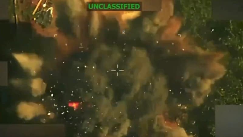
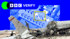
Iran attacks damage 20 US military sites since start of war, satellite images show16 minutes agoShareSaveAdd as preferred on GoogleMerlyn Thomas,Alex MurrayandMatt Murphy,BBC VerifyBBCIran has damaged 20 US military sites since the start of the war, satellite images and videos analysed by BBC Verify show, suggesting the attacks are more extensive than publicly acknowledged.Iran has targeted key facilities across eight countries in the Middle East since the end of February, causing millions of dollars of damage to state-of the-art air defence systems, refuelling aircraft and radars.Tehran has targeted both US bases and shared military facilities in retaliation to the US-Israeli strikes across Iran and Lebanon over the past three months. The Pentagon says it has hit more than 13,000 targets in Iran since the start of Operation Epic Fury.Mojtaba Khamenei, Iran's supreme leader, has sought to highlight his military's success in striking US facilities. In a statement on Tuesday he claimed the Middle East was no longer a "safe place" for American bases.While the White House has repeatedly claimed that Iran's military has been almost wiped out, analysts said that the damage seen at US facilities suggests that Tehran's counter-attacks have been more precise and extensive than American officials have previously acknowledged.A US defence official declined to comment on BBC Verify's findings, citing "operational security reasons".The US has sought to limit satellite analysis of the conflict by requesting Planet, a major provider, to impose an "indefinite" restriction on new images of Iran and most of the Middle East. The company justified the move, saying that it wanted to ensure its images were not used "by adversarial actors to target allied and Nato-partner personnel and civilians".BBC Verify has used satellite imagery from other international providers combined with older images from Planet to track the damag...المصدر: BBC News | Source: BBC News
ملاحظة تحريرية | Editorial Note: نُشر هذا المقال في الأصل بواسطة BBC News. خبر (Khabr) هي منصة إعلامية أردنية مرخّصة تعمل بالذكاء الاصطناعي. نضيف قيمة تحريرية من خلال: تحليل ذكي للأخبار، ملخصات تلقائية، رواية صوتية بالذكاء الاصطناعي، ترجمة متعددة اللغات، وتدقيق الحقائق. هدفنا جعل الأخبار أكثر وضوحاً وسهولةً للقارئ العربي.
This article was originally published by BBC News. Khabr is a licensed Jordanian AI-powered news platform (Registration #82086). We add editorial value through: AI-powered news analysis, automated summaries, AI audio narration, multi-language translation (Arabic, English, French, Turkish), and AI fact-checking. Our mission is to make news more accessible and understandable for Arabic-speaking audiences worldwide.